Sunday, April 28, 2013
Wabash River flood, high water marks of April 20, 2013
This is the Wabash River at Williamsburg Pond the morning of April 21, 2013. The river crested at about 25. 6 ft. in the evening of April 20 and here is receding. The line of debris marks the high water point
Link to Wabash River levels:
High water mark visible on the lower beam of the wooden fence. At its peak the river water reached just to the seat of the park bench.
The Wabash River gauge at Brown St. overlook, morning of April 21
The Brown St. overlook and gauging station, looking from the Lafayette side of the Wabash, morning of April 21.
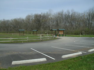
Trailhead at McAllister Park, Lafayette, very near N. 9th St. Line in the parking lot marks the extent of the river flooding the night before, here the floodwaters are receding. Afternoon of April 21, 2013. Another foot higher and 9th St. would have been underwater.
Wabash River floodwaters, evening of April 21, 2013, view of State Road 26 bridges from Tapawingo Park, West Lafayette. The current at the middle of the channel is rapid enough to be clearly audible from the bank here.
Subscribe to:
Post Comments (Atom)


No comments:
Post a Comment